Skyty logo with an orange stylized mountain icon and the word 'Skyty' in white and black text.

Turn Intelligence Into Action

SkyTL transforms complex real-time data into actionable decision making, empowering you to predict, prevent, and protect against natural disasters.

Complete Disaster Response Lifecycle

From prevention to recovery, SkyTL supports every phase of disaster management, empowering organizations, agencies, and communities to act with confidence..

An aerial view of a flooded area with water covering roads and buildings, including temples and houses, surrounded by green trees and vegetation.

Before Disaster Strikes

Reduce risk through simulation, hazard mapping, and proactive mitigation strategies across multiple disaster types

Risk Management

Preventive Planning

A forest fire burning trees with flames and smoke.

During Active Events

Real-time alerts, evacuation guidance, and disaster spread predictions when every second counts for community safety

Evacuation Guidance

Dynamic Forecasting

Electric power substation with high voltage towers and wires under a partly cloudy sky at sunset.

Infrastructure Protection

Safeguard critical infrastructure with targeted shutoffs, maintenance scheduling, and resilience planning

Asset Protection

Liability Mitigation

Construction workers use a crane to demolish a building debris after a storm, with a house and palm trees in the background.

Disaster Response and Recovery

An advanced decision-support tool that optimizes multi-asset mission planning, execution, and safety in high-risk environments

Community Support

Grant Assistance

Meet Our Products

Two specialized solutions delivering advanced science and intelligence to support decision-makers across industries and missions.

Screenshot of the WindTL wildfire intelligence platform displaying a 3D terrain map with data overlay, with an orange label indicating it was used during the Thompson Fire.
Map with a grid overlay and orange and yellow color coding, titled 'Built for Axiom Mission 4'. Overlay text indicates ForeTL, Space Companies, Coast Guard, DoD, and Mission Risk Management. The image includes a sidebar with options like open inputs grid, submit, risk layers, and launch names. Below is a description detailing advanced decision-support for high-risk environments such as space missions, search and rescue, and natural disaster response, emphasizing real-time data, dynamic risk scores, route optimization, and decision support.

Discover how our innovative solutions are making a real-world impact through cutting-edge technology, strategic partnerships, and life-saving applications.

Technology Success Stories

July 2025

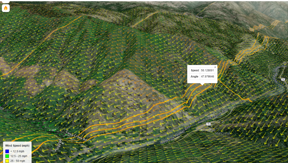
WindTL Predicts Fire Spread from Real-Time Aerial Mapping

How WindTL pioneered the first commercial use of in-flight fire mapping to predict fire movement in real time, delivering critical wildfire intelligence with unprecedented speed during high-stakes wildfire events.

Map showing navigational data over the eastern coast of the United States and Atlantic Ocean, with colored markers and a popup displaying feature properties, including distances and orientation metrics.

May 2025

ForeTL Enhances Mission Safety

Empowering safer space missions, smarter rescues

A man seated in an office with computer monitors displaying maps and data, and a drone on a table next to him. He is wearing a white polo shirt with a logo and is identified as Alex Rodriguez, Software Engineer at Improving Aviation.

March 2025

How SkyTL is partnering with Google to predict and combat wildfires

Topographic map showing wind flow over a hilly area with yellow arrows indicating wind direction and speed, primarily between 25-50 mph, with overlays of roads and a river.

July 2024

WindTL forecasted the Thompson Fire’s embers jumping the river hours in advance

  • "I'm in awe of what Rocio Frej Vitalle and her startup, SkyTL, are doing with AI to revolutionize wildfire response. They're using sophisticated AI on Google Cloud to provide firefighters and communities with real-time predictions that are already proving to be faster and more accurate than traditional models. This is a powerful example of how technology can be used to protect lives and property from the growing threat of wildfires"

    Lisa Gevelber - Global Vice President, Google

Item 1 of 8

Backed by leading organizations

Google logo with a multicolored G featuring red, yellow, green, and blue segments.
NOAA logo with a stylized bird in flight inside a circular blue emblem.
United States Air Force emblem featuring a bald eagle above a shield with a lightning bolt and wings, surrounded by stars and a gold border.
Roddenberry Foundation logo with a stylized globe and a curved line forming a 'R' shape.
Embarc Collective logo with black text and design elements on a white background.
NASA logo with blue background, white text, and red swoosh with stars and orbital lines.
Tampa Bay Wave logo with stylized waves in blue, green, and teal above the text 'Tampa Bay Wave'.
Contr Costa County Fire Department badge with American flag, California state flag, mountains, and fire service symbols.
Text-based logo reading 'the florida high tech corridor' with 'the' and 'corridor' in green and 'florida' and 'high tech' in black.

Ready to see SkyTL in action?

Experience how our platform empowers your organization with a personalized demonstration tailored to your specific needs.